|
The Plant Survey - Parish Rye
A Condensed Project History - Who, What, How, and Why
See the 2018 Parish Rye Maps HERE
See the 2018 Genus and Species Inventory HERE
Read the Interview with Parish Rye HERE
 |
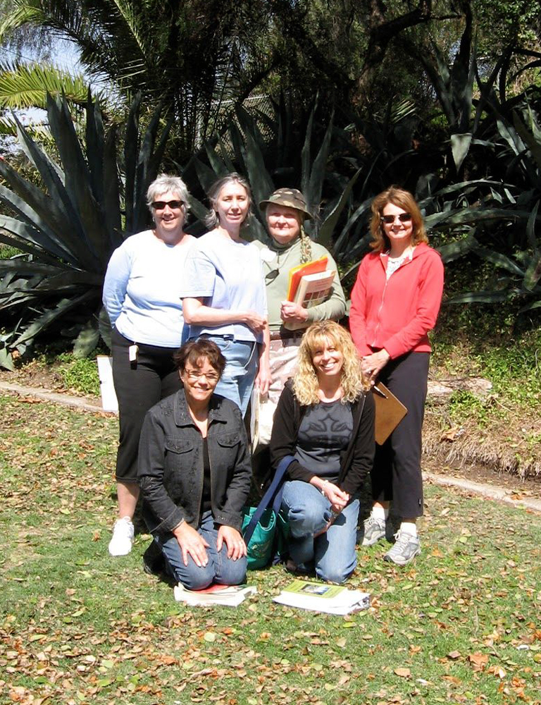
 San Diego Master Gardeners Association involved in the project. (Back row, left to right) Kathy Jones,Terri Skwarlo, Carol Jean Wolcott, Gretchen Yeager; (Front row, left to right) Meredith French, Tammy Hermes |
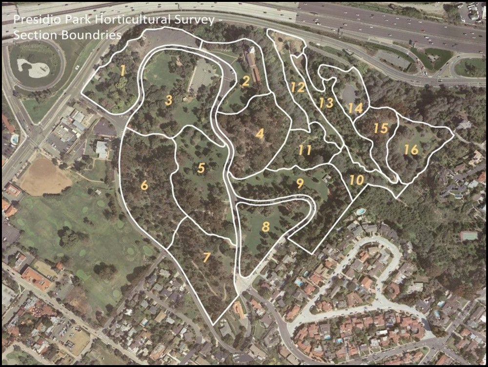
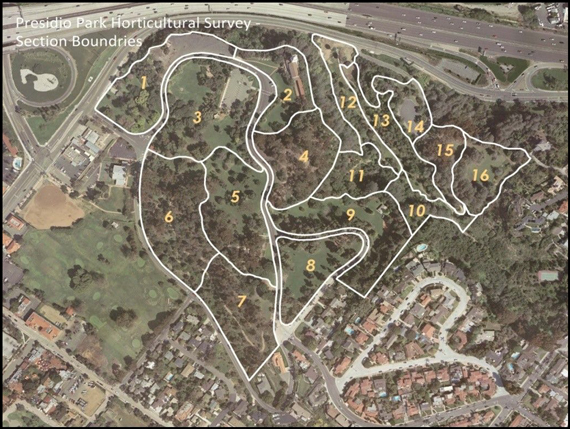 The park was subdivided into 16 sections based on topography, ease of access, trail locations, street layout and lawn areas. |
Six members of the San Diego Master Gardeners Association saw a need in Presidio Park. They discovered that there existed no accurate count nor an inventory of the horticultural treasures of Presidio Park. Presidio Park is filled with a very diverse horticultural palate of natives and non-natives. It is common for visitors to meander through the park and come across a tree or bush that interests them that they are perhaps not familiar with. But until now there was nowhere to go to learn what the plant might be.
The region around Presidio Park has been under human foot for thousands of years. First by the local indigenous peoples, the Kumeyaay, and then later by Europeans: Vizcaíno, Cabrillo, and eventually by Junípero Serra who established the first European settlement on the west coast of the United States. Urban legend tells us that the first imported plants to California were African date palms planted by Father Serra in Presidio Park in the late 1700s. These African date palms died in the late 1950s. There is a plaque at that location near Taylor Street commemorating these palms.
Today the horticultural landscape is very diverse. A thorough plant identification of Presidio Park was badly needed and resulted in the discovery of many interesting plants as well as the documentation of plants that no one knew grew there.
It was with that original volunteer core group that a plan was formulated and implemented. The park was sub-divided into 17 sections (section 17 was later dropped due to inaccessibility of the section). The size and boundaries of the sections were based on topography, ease of access, trail locations, street layout and lawn areas.
The first section to be surveyed was area 12, also known as Palm Canyon. It was agreed upon that the north end of the section should be cordoned off by ropes creating rectangles, and then further subdivided into small squares. and that each square should than be surveyed individually and the corresponding plant data manually transferred to a paper satellite image of the area. It was quickly evident that this method was creating too much focus on too much detail, was impractical to set up ropes on slopes and under tree canopies and was very time consuming. This approach was quickly abandoned.
Thereafter, 11" x 17" printouts of each sections' satellite imagery were utilized. Using the satellite imagery and the plant knowledge of the core group plants were identified by genus, species, and common name using "X's", arrows, circles and a pencil, walking through each area identifying as many plant species as possible. This resulted in the observation of many plants previously not known to have been growing in Presidio Park.
We began creating lists and excel documents for each section, slowly giving us a glimpse into where the project was heading. As these lists began to take shape it became clear that certain data was more important than other pieces of data. It was agreed upon that there were six pieces of information per plant identified that would be important and of interest to the general public at the conclusion of the Presidio Plant Identification Project, and they are; genus, species, common name, native or non-native, location of origin and a 1969 historical teference number, if possible.
The excel documents were a work in progress. Research was sporadic but consistent and as the blanks were filled in it became clear that Presidio Park harbored interesting plants from all over the world. As we progressed through each section some of the unknown plants that were found, were identified by various experts using clippings, photos or field visits. This helped as we progressed through other sections, finding these same plants, we now could gradually identify more and more plants. We then went back and identified those other unknown plants in the other sections. This was repeated numerous times.
As we neared the end of our walkthrough of all the sections we were still left with many unknown plants. The majority of these unknown species were found in the eucalyptus, acacia, opuntia, aloe and agave genera.
It was at this time a generous donation to the project was made by one of the core members. It was decided that G.P.S. technologies be utilized to document, enumerate and map all the plants in the park. A Trimble handheld GPS device was donated for the purpose of GPS'ing all the plants. Thus began the journey of learning, using and applying geographic information systems technology to the Presidio Park Plant Identification project.
A database was created and then uploaded into the GPS unit. In the field, every plant previously documented on paper was revisited and a GPS reading was taken to then be transferred to ESRI ArcMap for data processing and eventual map production. The learning curve for this technology was tremendous, and continued throughout the entire process.
Simultaneously, throughout the entire process, was the researching of the unknown plants. Hand drawn maps were created of "unknown" eucalyptus, of "unknown" opuntia, of "unknown" acacia and of all other "unknowns". There were several members of the core group who assisted in identifying some of the unknown plant. Additionally, several City of San Diego horticulturists, botanists, and tree experts donated time in the field identifying the plants of their field of expertise. Eventually, the unknown plants became fewer and fewer until only a handful remained. There was also assistance procured from experts at the San Diego Natural History Museum, the Horticulturist at the San Diego Zoo, Professor and Director of Cal Poly Plant Conservatory, as well as knowledgeable staff at Walter Andersen Nursery—San Diego.
Over the course of time every single non-grass, growing plant in Presidio Park was identified, with only a tiny few remaining unidentified.
Additionally, photographs of each species were taken over the course of several years in an attempt to capture the flowering. All photographs were taken in Presidio Park of Presidio Park plants.
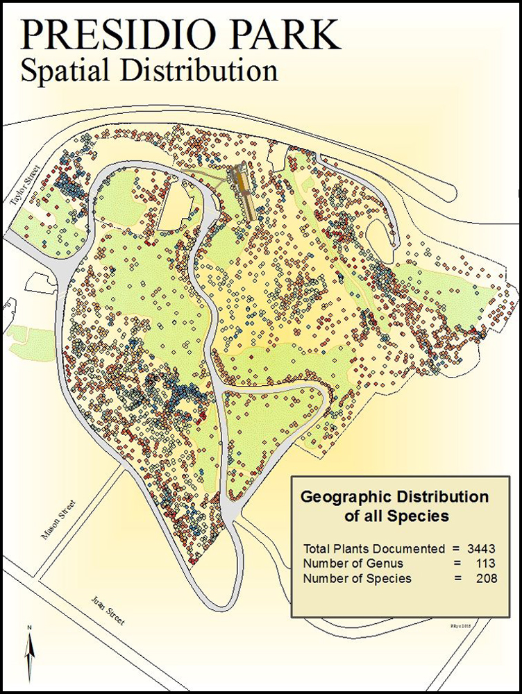
All the plants were imputed into GIS technology to produce maps as well as for providing a valuable data bank in which to analyze the information for use in this publication and for the good of public consumption.
After having identified and GPS'd the majority of the plants GIS assistance was procured from the San Diego State Geography Department. Several graduate students assisted with data processing and map production. The data was shared with these student who used it to satisfy graduate work within the department.
At the conclusion of the field data collection multiple maps were created by the author using ArcMap 10.0. A portion those maps can be found within this report.
Volunteer Hours
The original core group logged more than a thousand hours, dozens more were spent by the others involved in plant identifications, and approximately 250 volunteer hours were logged by technical staff in the production of maps, and in the learning and teaching of the ArcMap software produced by ESRI.
See the 2018 Parish Rye Maps HERE
See the 2018 Genus and Species Inventory HERE
Read the Interview with Parish Rye HERE |