|
Tragedy Unfolds
A Federal plan without foresight
By Victor A. Walsh
The sun warms my back as I walk down the horse trail toward the beach. The sky is a transparent pale blue, specked with thin white clouds. Clusters of squealing gulls are circling overhead. At the end of the trail near the dunes, several native Belding's Savannah sparrows are quietly rustling in the pickle weed, one of six endangered birds that nest in the Tijuana River estuary. Beyond the footbridge to the beach, the estuary is marked off for the Western snowy plover and California least tern, two endangered shore birds that breed here during spring and summer.
I walk further south along the beach toward the US-Mexico border. A US customs and border patrol agent sits in his vehicle atop Monument Mesa overlooking the beach. A phalanx of tall steel pilings, representing the border, juts out onto the sand. On the opposite side, bystanders have gathered on a cliff to snack beneath a group of circling gulls.
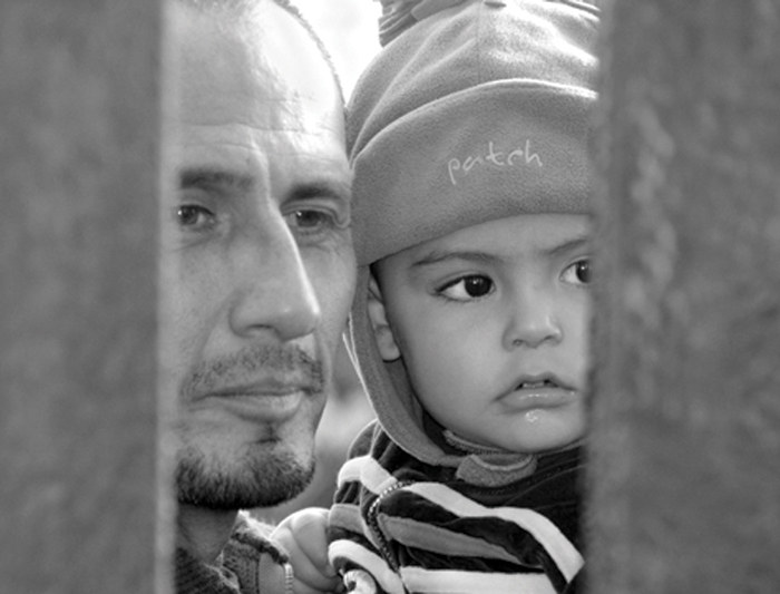
Father and son seen through the border fence. Photo by Karl Hoffman
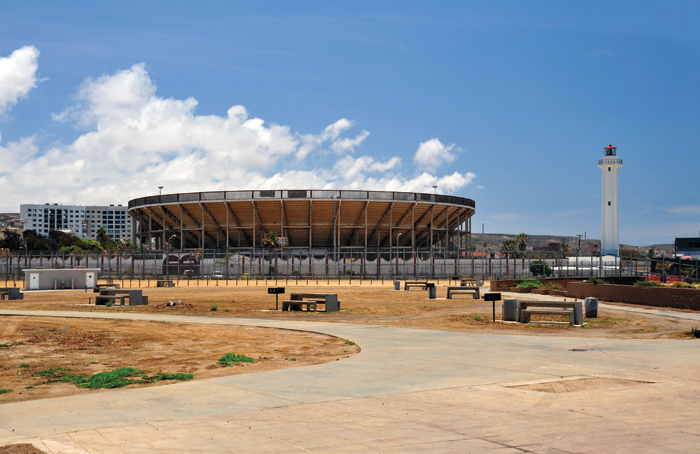
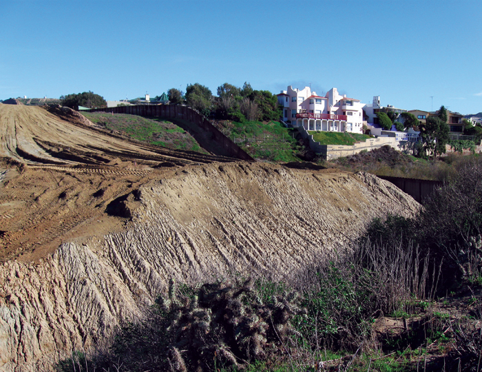
The park has been denuded of virtually all vegetation, leaving the soil open to erosion and run off, sidewalks are covered in dust blown from the exposed beds. Photo by Sandé Lollis
On August 18, 1971, First Lady Pat Nixon visited the mesa to inaugurate the creation of Border Field State Park. Hundreds of people assembled on both sides of the border to witness her visit. After dedicating the new park, the First Lady requested a member of her security detail to cut a section of the barbed-wire barrier so that she could greet the Mexican children on the other side. She told them, "I hope there won't be a fence here too long."
Her gesture of goodwill ultimately defined the park's purpose. Over the years, people from Mexico and the United States have gathered around the monument to visit through the border fence. The quarter-acre area is called Friendship Park, a place where families and friends, some of them here illegally and some unable to even cross the border, could reunite, exchanging news, tamales, and kisses through holes in the chain-link fence.
On January 6, Customs and Border Protection announced that Friendship Park would no longer be opened to the public since it is now part of the construction zone to complete the final 3-mile section of the triple fence to the Pacific Ocean. The ban on public access will remain in effect after construction is completed in May 2009. What has been a celebrated meeting place around an international boundary marker has become, quite literally, a no-man's land.
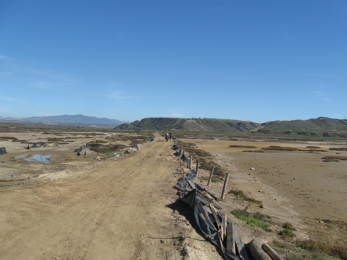
Horse trail showing evidence of recent flooding. Photo by Melvin Sweet
Nothing remains of Friendship Park. The lawn, the stone picnic benches; the stabilized adobe perimeter wall are no more. Instead, a swath of churned-up earth at least a 150-feet wide cuts through the southern portion of the mesa and then plunges down to the beach. On the far side, stands what remains of the paved walkway and the monument or marker. It is, and I say this with profound regret, a living symbol of U.S.-Mexican history, a national landmark without a homeland.
The Italian marble obelisk has stood here since October 10, 1849. Embedded in its foundation is a copper tube containing two parchment documents, one in English and one in Spanish, commemorating the occasion. The monument is only one of three boundary markers listed on the National Register of Historic Places.
To the east, Yogurt and Goat Canyons have been filled with dirt, while the mesas, including the 150 foot-high Spooner's Mesa above Smuggler's Gulch, have been cut and leveled in order to build an all-weather patrol road parallel to the fence.
The road and secondary fencing will swing around the three World War II coastal defense bunkers atop Bunker Hill, but they will be inaccessible and unprotected because the DHS does not plan to rebuild or reinforce the existing fence.
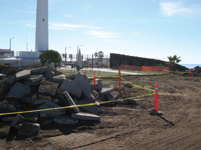
The destruction of Friendship Park. Photo by Melvin Sweet
|
Massive earth movement for construction of building the border wall, creating a permanent scar so large and deep it can be seen from downtown San Diego and from space. Photos by Melvin Sweet
|
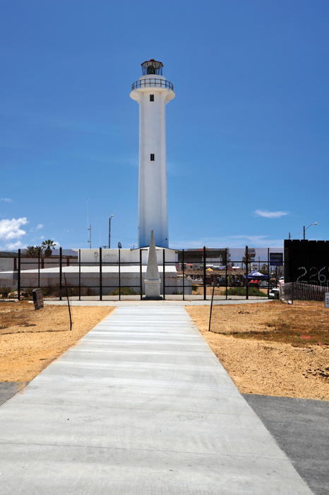
Taken through the bars of the new fence, this is as close as anyone can get to the 1849 monument that is at the heart of Friendship Park. The inscription reads: "Initial point of boundary between the United States and Mexico, established by the Joint Commission 10th October, A.D. 1849, agreeably to the treaty dated at the City of Guadalupe Hidalgo February 2, A.D. 1848. John B. Weller, U.S. Commissioner. Andrew B. Gray, U.S. Surveyor." Photo by Sandé Lollis
|
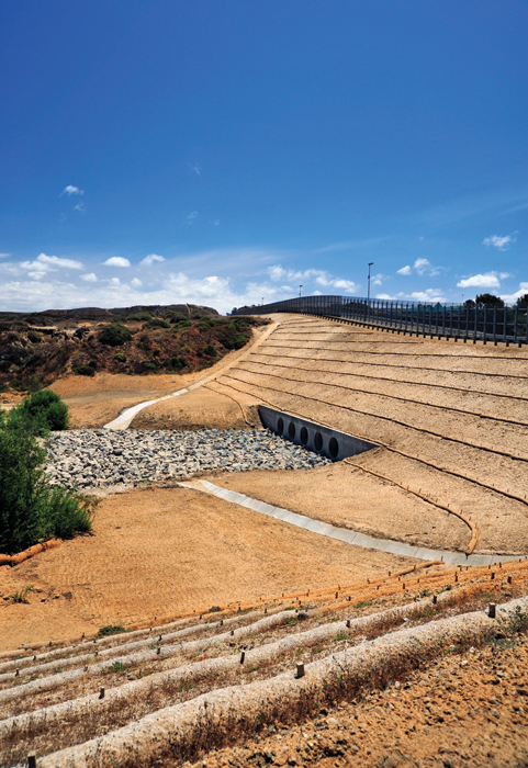
Smuggler's Gulch, filled and completely obliterated. Photo by Sandé Lollis
|
Over the next several months, Kiewit Construction will grade and lay the final stretch of roadway and build additional fences made of steel-mesh and chain-link flanking the road on the north side. Lights, sensors and cameras will span the length of the project. The Congressional Research Service estimates that the total construction cost will exceed $21 million per mile or slightly less than $75 million.
The destruction of a state park once dedicated to border friendship in the name of homeland security and border militarization both saddens and angers me. Construction of additional fencing and roads will limit or prevent public access to many historic and cultural resources, while putting others, including California Indian archeological sites, early Spanish exploration and settlement routes, and remains of early ranches, at risk.
It is an abuse of constitutional restraints placed in the power of the executive branch. Under the terms of a 2005 act of Congress, former Department of Homeland Security (DHS) Secretary Michael Chertoff waived over 30 federal, state and local laws, which he believed would obstruct the "expeditious construction" of the triple fence in San Diego County. The project is exempt from all environmental laws and regulations, including federal and state inspections and permits.
It is a misuse of taxpayer money because apprehensions in the two western-most stations of the U.S. Customs and Border Patrol in San Diego County have dropped by 94% since 1994 when Operation Gatekeeper went into effect. Border-crossings near the San Diego coast have been brought to a virtual halt.
Additionally, it imperils the very existence of the Tijuana River Estuary, one of the few saltwater marshes remaining in Southern California. Home to over 370 species of migratory and native birds, the estuary has been declared a Wetland of International Importance by the International Ramsar Committee. Approximately $50 million in public funds have already been invested to conserve and protect it.
Over 70 acres of habitat, including coastal sage scrub and the rare maritime succulent scrub plant communities, are being destroyed as a result of this project. At least 53 rare and endangered plants and animals live within the footprint of the new border corridor.
Even with implementation of best management practices, sediment runoff from the cut slopes will flow into this internationally acclaimed estuary and impact the ebb and flow of coastal tides upon which it depends. California State Parks claims that upwards to 85 acres of bare soil will be exposed to major erosion during and after construction. The cost to remove sediment in 2007 exceeded $20 a cubic yard, while the cost to restore an acre of habitat ran about $350,000.
Unfortunately, sound erosion and sediment control practices have not been followed. In a letter to the Army Corps of Engineers, dated October 21, 2008, the State Water Resources Control Board noted that there was no Storm Water Pollution Protection Plan in place or even temporary erosion control measures on site. It also stated that every access road was so poorly designed for drainage that runoff would occur during normal rainfall, let alone major storms. Philip Williams & Association, a San Francisco-based environmental hydrology firm, estimates that sediment runoff into the estuary will increase three-fold from about 500 tons to 1,500 tons per year if erosion control measures are ignored or unsuccessful. Such an outcome would destroy the habitats, the sloughs, wetlands, and dunes, of countless animal, plant, and marine species.
Contractors are now covering the cut slopes with a plastic, mesh-like matting called Enkomat and hydro-seeding them to reduce erosion. The critical question, one raised by California State Park environmental scientists early on, is whether the seeds can germinate given the dry climate, harsh growing environment, and terrain's rill and gully contours.
The history of erosion, sedimentation, and flooding along the Tijuana River on both sides of the border make the success of such a massive earth-moving project improbable. In 1916, for instance, a massive flood along the river demolished San Ysidro and Tijuana, California; the latter no longer exists. The soil of the border highlands is largely clay pan and shallow soils layered over nearly impervious materials. The area also boasts one of the driest climates in the county. Both of these factors will complicate efforts to effectively replant the slopes and mitigate surface runoff and erosion.
Furthermore, building an elevated patrol road atop cut mesa tops and filled gorges creates a new problem of controlling rising water levels down the Tijuana River during major storms. The Army Corps and its contractors are now building 12 culverts, including a 680-foot long goliath at Smuggler's Gulch, designed to discharge water for upwards to 24 hours during a 100-year storm. What will happen if one or more of these culverts clogs with debris? The water level would quickly rise destabilizing the road and, in a worse case scenario, cause backwater flooding on the Mexican side, jeopardizing life and property. Neither the Environmental Impact Report nor the Final Drainage Report for this project contains a backup plan.
Construction of the triple fence at Border Field is a lasting testimonial to the politics of fear that has gripped our nation's consciousness since the 9-11 tragedy. In this context, it represents a disturbing irony. During the Second World War, Border Field became an integral part of the region's coastal defense system. The U.S. Navy established Border Field Auxiliary Landing Field, an operation that included thirty-five buildings, a machine-gun range, and observatory towers to conduct aerial gunnery practice below Monument Mesa. The footprint still exists, and in this context, is a valuable historic site, provided it is not disturbed, an unlikely outcome due to erosion and sedimentation processes, which the triple fence will surely exacerbate.
The Friends of Friendship Park continues to lobby the Obama Administration to develop a plan that allows public access to Friendship Park without jeopardizing the security and safety of this quarter-acre section of Border Field State Park.
The Second World War was a far more perilous time than today in terms of threats to our nation's security. It was a time when the United States feared that Japan might launch an invasion by land and sea from Baja California, a time when Axis U-boats sunk merchant marine vessels off the Pacific coast; a time when cities and towns endured evening blackouts. It was a time that should be remembered, not forgotten.
As a consequence, a park, a rare ecosystem, and a regional heritage are being waylaid for the sake of political expediency and supposed national security. These things are irreplaceable, and to lose them without considering a less destructive and more comprehensive alternative that exists is the height of human folly.
About the author Victor A. Walsh is the District Historian of San Diego Coast District, California State Parks. His publications on state and national parks have appeared in Our Heritage magazine, Christian Science Monitor, San Antonio Express-News, Arizona Daily Star, San Diego Union-Tribune, Voice of San Diego, Coast to Coast, and Desert Leaf.
|
MORE FROM THIS ISSUE
From the Editor
2009 People In Preservation Award Winners
Historic Preservation & Environmental Conservation
The Green Game
Making your historic home more energy efficient
Your home's landscape is green in more ways than one
San Diego Trust & Savings Bank Building
Black Gold in San Diego
2009 Most Endangered List of Historic Resources
Tragedy Unfolds
Preservation Community
Reflections
Recognition
The Whaley House Porch Returns
Museum News: Marston House
Borrego Springs Modern lll
Borrego's future lies in its past
Adobe University
An Enchanted Evening at PIP
Looking for historic homes, gardens or commercial sites
Help Us
Lost San Diego
Strength in Numbers
Advertisements
DOWNLOAD full magazine as pdf (9.7mb)
|